In the Footsteps of the Samurai: Walking the Nakasendo
By Deborah Klens-Bigman, Ph.D.
Editor’s Note: This
is a first hand account of the author’s expedition along the famous
foot path that in Samurai Japan connected the two great centers of Japanese
power, culture and civilization.
I picked my way
Through a mountain road,
And I was greeted
By a smiling violet.
Basho (1644-1694) (1966, 62)
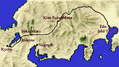
The Nakasendo (literally, Center Mountain Road) was, and is, an Edo period
(1603-1867). highway, one of five built to connect areas of Japan. Originally,
the Nakasendo linked Kyo (Kyoto), in the east to Edo (Tokyo) in the west,
and as the name implies, ran through the center of Honshu (the largest
island of Japan, called the Mainland). Like its better known cousin, the
Tokaido, which ran along the Pacific coast, the Nakasendo provided a valuable
link for commerce as well as official government business. Some 30 daimyo
(powerful feudal lords who ruled over domains, or hans, and had retainers
–Samurai. In modern times hans were replace by a prefecture system)
and their attendants, as well as lesser samurai, merchants, commoners,
royalty and imperial officials, traveled the Nakasendo throughout the
Edo Period. It provided a principle political link between the city symbolic
of both the emperor, and cultural (Kyoto) and the Tokugawa military capital
(Edo) from where the Tokugawa Shoguns (a hereditary title and rank given
to the head of the military government) controlled the country.
With the coming of modern transportation, all of the "highways",
including the Nakasendo, declined in importance, along with the post towns
(towns were built along major highways to accommodate and cater to travelers)
they linked together. But, like historical artifacts in much of Japan,
traces can still be seen amid the detritus, or disintegration, of modern
life. Today, the areas still linked by the remaining parts of the Nakasendo,
running through the Kiso Valley, are neither large nor important in the
grander scheme of things, but sections of the highway have been maintained
as hiking paths. It was one of these portions, linking the post towns
of Magome and Tsumago, inspired by an article in the New York Times, that
I decided to pursue.
I arranged to take the trip in the summer of 2005, on the way to Koyasan
(Mt. Koya), the seat of Shingon Buddhism. I was on my way there for a
memorial service honoring my teacher, Otani Yoshiteru, who had died the
previous year. Given the nature of my task at Koyasan, I felt that I should
do something solitary in preparation - something physical that required
some effort, before undertaking what I was sure was a difficult spiritual
mission.
In addition, as an iaido practitioner, I am of course interested in Edo
Period samurai culture. What better way to learn more than to spend a
morning walking the same path so many samurai had trod before?
"Where?" my travel agent asked when I told her what I wanted
to do.
"Magome one night, Tsumago the next," I said, pushing a copy
of the NYT article across the table to her.
I was further intrigued when I did a little web research on the two towns.
Tsumago proudly mentioned that it was a "museum town." Magome
made no such claim. Interestingly, in their little profiles on Japanese
tourist websites, they scrupulously avoided mentioning each other to any
extent. Given that the two towns were about a half-day apart on foot,
was there some rivalry in the past that still echoed now, more than a
hundred years after the end of the Edo Period? Maybe I would find out.
After several days in Tokyo, I prepared for my trip. I stuffed four days'
worth of clothes and toiletries (just barely) into a day pack, checked
my large suitcase at the hotel, and took off. First by Shinkansen (high
speed train) from Tokyo to Nagoya, then by train to the medium-sized town
of Nakatsugawa. At that point, I needed to take a city bus. I found the
bus stop near the town center. There, with not many middle-aged white
women around, I provided some novelty for the senior citizens on the bus,
clutching their bags of groceries from early-morning shopping. Together
we made the trip up the side of the mountain to Magome-juku, as the town
is more properly called.
Magome literally hangs off the side of the mountain. The only level part
of town was the large bus park where the local bus pulled around and dumped
us off. Large, luxuriant tourist buses were parked around the edges of
the lot. From there, everything was narrow and essentially vertical.
Next came the awkward telephone conversation with the owner of the minshukan
(a guest house, like a ryokan, or a traditional Japanese inn) where JTB
had made my reservation. After I got hopelessly confused by the directions,
the proprietress finally gave up and came to pick me up in her minivan.
We wound up the side of the mountain past some rice fields at the very
remote edge of town. The sleeping quarters had clearly seen better days,
but the dining room was meticulously kept and traditionally rural, with
tatami floors and a fire pit. Traditional guest houses are famous for
their cooking, regardless of where they are located. An ample garden of
local vegetables out front suggested some interesting possibilities for
dinner.
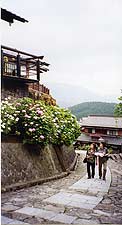
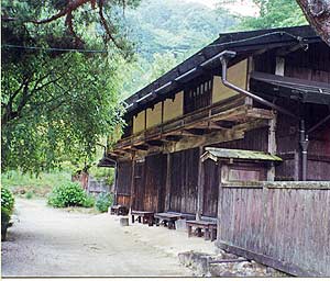
|
The quaint charm of Magome-juku. |
After settling into my room, I walked back down the twisting road to
check out the beginning of the hike I would take tomorrow, as well as
a possible place for a late lunch. It was not difficult to find the former;
a cobbled walkway zoomed straight up the side of the mountain, right through
the middle of town. After thinking about it for a little while, I settled
on a touristy restaurant at its base, from which I watched a small but
continuous stream of visitors flowing past me to the bus park down below.
Wow, I thought, in spite of the steep grade. So many people and they weren't
even out of breath. How hard could this be?
I had visions of all those samurai movies and television shows featuring
lots of people on horseback, litter and foot, little bundles under their
arms or on their backs, happily trotting down the wide, level road that
really looks like a road. Though the packs had now been replaced by shopping
bags, I figured my Nakasendo experience would be somewhat similar, in
spite of the name.
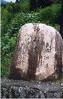
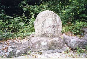
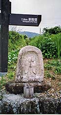
|
One of the many old road markers for the Nakasendo.
|
After lunch, I trudged up the slope to take a look around. The buildings
were pretty, but modern, most fronting souvenir shops - from local crafts
to things that were definitely from out of town. Everything was pricey
to boot. There was no sense of Edo Period life that the Times article
suggested, unless the definition of Edo Period life was decidedly loose.
The town center ended with a highway at the top and yet another bus park.
Aha. The undaunted tourists were simply getting off at the top and shopping
their way to the bottom while their buses were pulling around below to
pick them up again. On the other side of the highway, the cobbles disappeared
under a thick blanket of leaves, still going straight up. A marker that
said, simply, "Nakasendo" identified it as my route. Maybe this
would not so easy after all.
The minshukan proprietress, after learning of my plan, commended my sense
of robustness, but pointed out it might have made more sense to come from
Tsumago-juku, since the way from Magome-juku is much steeper going. Oh
well, too late now. After an unsurprisingly superb meal, I retired early
in preparation for the day ahead.
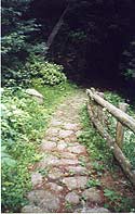
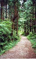
|
The Nakasendo, winding into the trees.
|
The next morning was not very warm, but definitely sticky. Suyu, the
rainy season, was in full swing. I would have been wise to swap my carefully
packed sunscreen for some insect repellant, but I opted for pants and
a shirt with sleeves instead. After an equally excellent breakfast, I
was off - down the twisty road again, to go up through Magome-juku. I
could have started at the top of the town instead, but I wanted to go
from the beginning of my Yellow Brick Road. Magome-juku was barely stirring
at 8:00 a.m. as I began my journey, the little souvenir shops still quietly
shuttered, and no tour buses in sight.
I soon made it through the town and crossed the highway, up into the
trees. The going was certainly steep, but not rough. From time to time,
the paving stones gave way to stamped earth, covered with leaves and pine
needles; other times the steep grade was replaced by stairs (probably
a recently-added feature). All around, trees stopped what sunlight there
was. However, it was not quiet. I could hear the sounds of cars speeding
by occasionally, even though I could not see them, along with rushing
water, birds singing, and insects, incessantly, buzzing. The minshukan
obasan was right; the way was unbrokenly steep for most of the first half
of my 7.7-kilometer journey.
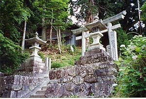
|
The shrine by the side of the road.
|
At one point, however, I was in fairly open country, surrounded by rice
and vegetable fields. A Shinto shrine was nearby, which I explored. More
interestingly, there were little statues and monuments along the route.
People here and there had left behind little piles of pebbles. One simple
carving, much weathered, depicted a man and a woman, standing together.
Over the man's head, the sun; over the woman's, the moon. In all likelihood,
people from a hundred years ago and longer had gazed at the same roadside
image. I was beginning to feel the sense of time I had been looking for.
|
 |
Though it is difficult to see the figures, the
sun and moon are clearly visible on this old monument by the side
of the Nakasendo.
|
Another roadside image of male
and female. |
At one point, nearly half way through, the path evened out again. A closed-up
building, its unfinished wooden planking revealing its age, ringed round
with azaleas and other flowing shrubs, appeared. A (probably welcome to
some) outhouse was prudently placed on the opposite side of the path.
I thought the building was an old kissaten (a traditional tea house).
I have found kissaten in the remotest of places (the top of a mountain
that only hikers can venture up, for example). Literature available in
Tsumago-juku noted the presence of an old inspection station for logging
operations along the route. Not a soul around on a weekday morning, but
a beautifully tended garden in the middle of nowhere.
At several places, the Nakasendo combined with an actual road that led
through little villages nearly deserted, as residents no doubt worked
somewhere more populous. Occasionally, the route led through people's
back yards, which made me feel like an intruder. But if anyone noticed,
no one cared.
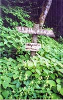
|
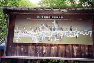 |
One of the many signboards along the route.
|
A map shows the entire length of this section
of the Nakasendo. |
A little more than halfway through, I was on top of the mountain (there
was nothing higher ahead of me) and the path crossed a two-lane highway.
A large signboard showed the entire route, from Magome-juku to Tsumago-juku
to Nagiso- juku beyond. If I had known, I thought, I could have taken
another day and trekked even farther. At this point, however, time did
not permit.
|
The road slopes gently down to Tsumago.
|
My feet and knees would not really permit, either. The minshukan obasan
did not know one thing about hiking: going down is definitely more difficult
than going up. The relatively gentle slope down to Tsumago-juku was much
tougher than the trudge up from Magome-juku. If I had gone in reverse,
the steeper slope would have been more difficult, and more slippery on
the wet rocks and damp pine needles. I had come the right way after all.
I met few people on the route; it was a weekday morning after all. One
or two real hikers, wearing gaiters (not needed except for going off route),
large multiday packs, better shoes than mine, and bells for warding off
bears. (The minshukan had posted multilingual warnings about bears. However,
I doubted very much that bells would be much use in any case if I met
one.) I also met some Europeans, similarly equipped. A middle-aged woman
with a camera and an overstuffed day-pack, I looked like a dilettante.
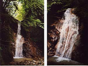
Not far from Tsumago-juku, I arrived at the O-Taki and Me-Taki (Male
and Female Falls). Though I was very footsore by this time, I trudged
down the stone steps to see them. Legend has it that Miyamoto Musashi
pondered the secrets of strategy during a visit here. I was humbled to
be in the memory of such distinguished company.
|
Me-Taki (left) and O-Taki.
|
[Photo 12 – Rip – please put Nakasendo012.jpg here. Caption:
Me-Taki (left) and O-Taki.]
As I left the falls, I encountered a group of Japanese day-hikers. "Hitori
desuka?" they asked. "Are you alone?"
"Eh." "Yes."
"Daijoubu desuka?" "Are you all right?"
"Mochiron" "Of course."
The steps to the falls were fortunately close to the last great vertical
of the day. Though I could have worn better shoes, I was still surprised
how exhausted the 3-1/2 hour hike made me. Truly, the porters who used
to do this for a living, as well as palanquin-bearers, servants, and even
mounted samurai (who would have had to walk their horses much of the way)
were sturdy folk indeed. Basho, the wandering Zen poet, traveled this
area in 1687, and remarked, “the Kiso road…was steep and dangerous,
passing over a number of high mountains” (1966, 91). Indeed.
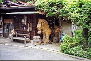
|
A straw horse stands guard outside a small restaurant
in Tsumago-juku.
|
About The Author:
Deborah Klens-Bigman is Manager and Associate Instructor of iaido at
New York Budokai in New York City. She has also studied, to varying extents,
kendo, jodo (short staff), kyudo (archery) and naginata (halberd). She
received her Ph.D in 1995 from New York University's Department of Performance
Studies where she wrote her dissertation on Japanese classical dance (Nihon
Buyo). and she continues to study Nihon Buyo with Fujima Nishiki at the
Ichifuji-kai Dance Association. Her article on the application of performance
theory to Japanese martial arts appeared in the Journal of Asian Martial
Arts in the summer of 1999. She is married to artist Vernon Bigman. For
FightingArts.com she is Associate Editor for Japanese Culture/Sword Arts.
|